
The following article was written by Bob Bunting, CEO, Climate Adaptation Center
If you find yourself longing for cooler temperatures and rain, here is why.
The record warmest May until now was in 2019, when the average temperature was 80.7º F. This year, that record fell hard as the average temperature was 81.4º F to mark the warmest May in our local recorded history. The average monthly temperature for May is 77.8º F so the 3.6º F above normal is literally off the charts!
Not only did we experience record heat, but the entire earth also went through its warmest 12 months in human history! We are living in an astounding time. As is often the case with record high temperatures, they occur more frequently with dry conditions. Just .02 inches of rain made this May the 3rd driest. Seriously though, .02 and nothing are about the same!

When looking at temperature, it is a good visual to see the daily temperature ranges and the record temperatures when they occur.
The brown shaded area are the normal ranges in the chart below. The red shaded area shows abnormally hot temperatures. The blue bars are the daily ranges. At the end of the month, we experienced 3 record hot days and on May 30, the 99º F high temperature tied the all time hottest temperature ever recorded in May in Sarasota.

What about the lack of rain?
Think about it, Hurricane Ian created the largest inland flood in at least 500 years in our area late in September of 2022. During that historic event up to 24 inches drenched the center portion of our state. In 2023, Sarasota experiences a severe drought with annual rainfall 23 inches below normal.
Although last winter was on the wet side, recent dryness has again pushed the middle and most of the southern portion of Florida into drought conditions.

Let’s talk about the near future
As is frequently the case, when a trend ends it can end with a bang. That is exactly what the CAC Annual Hurricane Season Forecast detailed at Hurricane Day held at USF-SM on April 4th is predicting for this hurricane season.
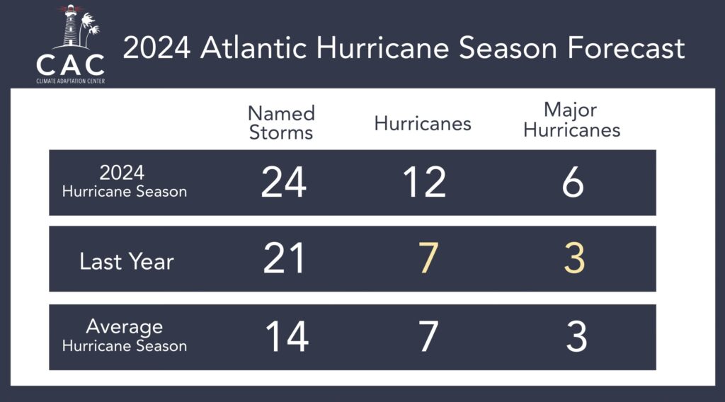
2024 Hurricane Forecast was released on April 4 at 10:50 am EDT and it calls for a very active hurricane season.
Since we released our hurricane forecast in early April, two other world renowned groups with deep experience in hurricane seasonal forecasts have issued confirming and essentially the same season forecast, including NOAA and Colorado State University.
We are deeply concerned about the combination of record sea surface temperatures, low wind shear and deep mid-level moisture in the Hurricane Formation Area that impacts Florida.
That is why the CAC is forecasting double the average of Major Hurricanes and 80% more hurricanes this season then is normal, even in our climate-warmed world.

Hurricane season is now underway
Although it has been quiet so far, a much more active condition looks to be evolving as early as next week.
That is why we are shifting from near record dryness to a wet environment in June and into the heart of hurricane season from July through October. I expect to see a storm named Alberto as early as next week as concerning pattern is already taking shape in the South Caribbean Sea which may spit out the first named storm next week.
The Gulf of Mexico is the target area and associated rain bands could bring needed precipitation then. Details will evolve over the days ahead and your CAC will be posting daily Hurricane Updates when storms threaten the Suncoast. You can get them by subscribing to our free newsletter here.
It’s time to prepare and be ready for what looks like an active season. We don’t know for sure what this means for Florida and the Suncoast specifically, but more rain is one good bet.
Sea levels rising quickly
By the way, sea levels since 2010 have risen at a very fast rate. Back in the last half of the 20thcentury, sea levels were rising about an inch a decade. Since 2010, our area has experienced 5 inches of sea level rise.
As we have seen on the Suncoast, it does not take a major hurricane to create major flooding in our metropolitan area. Eta (Nov 2020), Idalia (Aug 2023) and a regular storm last December created 3-to-5-foot storm surges that flooded portions of our barrier islands.
As sea levels rise, so too will storm surge flooding events. Minor tropical storms and Category 1 and 2 hurricanes are bigger threats now because of sea level rise.
Talking climate
The CAC is committed to the climate conversation. We do this with events like the Climate Champions Awards Ceremony, Hurricane Season Forecast Day and the upcoming Annual Climate Conference in November, that will focus on human health. We also give climate presentations, focused on adaptation strategies, to thousands of people throughout the year.
You can support us in helping our conversation going by making a donation or becoming a member.