
In October of last year, a tropical storm formed in the eastern Pacific and was named Otis. Hurricane models predicted the storm could become a Category 1 and strike the west coast of Mexico.
What happened was far different. Tropical Storm Otis became a Category 5 hurricane in just a day’s time. Moving over 90°F water, the storm rapidly intensified and moved inland into the heart of Acapulco, a city of 1 million, where little time was given to evacuate.
The city had never experienced a storm rated higher than Category 1. The result: scores dead and missing, and $35B in damage. I gave a 20-minute talk on this storm because I thought it might be a clue to the 2024 Atlantic Hurricane Season.
I recommend you watch it here.
Tropical Storm Beryl formed off the coast of Africa on June 28th. African-derived storms are highly unusual until late August.
The National Hurricane Center initially predicted the storm could become a hurricane before it traveled through the Windward Islands. No models or forecasters forecast a major hurricane, and certainly not a Category 5.
Noting this unusual storm, I was on high alert. Remembering Otis, my first question was, “Is this a sequel, this time in the Atlantic”. The rest is history, as you can see below.

Here are some of the records from this terrifying and historic storm. As climate records continue to be broken across the world every day in this record hot climate, here
are a few firsts for Beryl.
- The first tropical storm to form so far east in the Atlantic (off the coast of Africa) in June
- The first hurricane to form so far east in the Atlantic in June
- The first major hurricane to form from a wave coming off Africa in June and one of only 3 major hurricanes to form in June
- The first ever Category 4 ever to form in the entire Atlantic Basin (the Atlantic, Caribbean and Gulf of Mexico) in June, making Beryl the strongest June hurricane on record
- The earliest Category 5 to ever form in the Atlantic Hurricane Basin
- A record number or tornadoes from a hurricane landfall formed across Texas and Louisiana as Beryl moved inland
The storm struck land three times as a hurricane. First in the Windward Islands as a Category 5, then near Tulum, Mexico as a Category 2, and then came ashore as a segmenting Category 1 at Matagorda, Texas just south of Houston.
The GOES Satellite infrared image of Beryl as it became at Category 5 is shown below.

Texas experienced a major grid meltdown with 2.7 M households and businesses without power, along with serious flash flooding. With wind gusts to 97 mph and up to 14 inches of rain, this will be another $1B event for Texas alone.
Searing heat and humidity are creating an extreme heat event in Texas while millions are without air conditioning. Heat Index values are over 100°F.
Total deaths from Beryl are at least 14 with at least 6 in Houston. Damage and economic loss totals are estimated between $28B – $32B. More heat related deaths appear likely after Beryl.
Climate enhanced events like Beryl and severe heat are making an impact on all of us.
If you are not a newsletter subscriber, then click here to subscribe. You can also subscribe below in this story.
Remember, the 4th CAC Florida Climate Conference: Climate and Human Heath is coming up on Thursday and Friday, November 14-15, at USF in Sarasota at the new conference center. Tickets go on sale early in September.
I leave you with a reminder of the CAC 2024 Hurricane Season Forecast made the morning of April 4th. To watch it you can also click here.
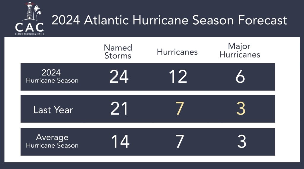
2024 Hurricane Forecast was released on April 4 at 10:50 am EDT and it calls for a very active hurricane season.