
It’s been over two weeks ago since Hurricane Beryl hit Texas. In Beryl’s wake, millions lost power for an extended period and Texas deaths have now climbed to 23 people.
Thankfully, since Beryl made landfall on July 8, the tropics have been very quiet in a season that’s forecasted to be extremely active.

Flooding after Hurricane Beryl moved through the area in Bay City, Texas, U.S. July 8, 2024. Courtesy: Kaylee Greenlee Beal
One reason for the recent calm in the tropics is the series of dusty air surges from Africa’s Sahara Desert, known as Saharan Air Layers (SAL). These SALs usually suppress development potential early in the hurricane season.
According to NOAA, the air within a Saharan Air Layer (SAL) contains about 50% less moisture than usual, hindering cloud and thunderstorm formation, which are essential for developing tropical cyclones.
However, this calm period is expected to soon end due to changes in tropical weather patterns starting in early August.
It’s typical
There are a few reasons for this expected change. Activity in the Atlantic Basin typically increases rapidly starting around mid-August, as ocean temperatures rise to their seasonal peak, wind shear drops to its annual low, and Saharan Air surges begin to decrease.
Also, late July lulls are statistically pretty normal.
The Madden-Julian Oscillation
NOAA’s Climate Prediction Center computer models indicate that the Madden-Julian Oscillation (MJO), a recurring climate cycle, will create more favorable atmospheric conditions for tropical storm and hurricane development in the Atlantic during the first half of August.
The MJO is an eastward-moving pulse of moisture and convection that affects regions along the equator and subtropics, taking approximately 30-60 days to circle the Earth at any given point.
The MJO increases tropical cyclone development by enhancing atmospheric moisture and reducing wind shear, creating more favorable conditions for storm formation and intensification.
Last August, a similar MJO’s rising air branch triggered four named storms in just 39 hours from August 19-21.
Extreme hurricane season still looming
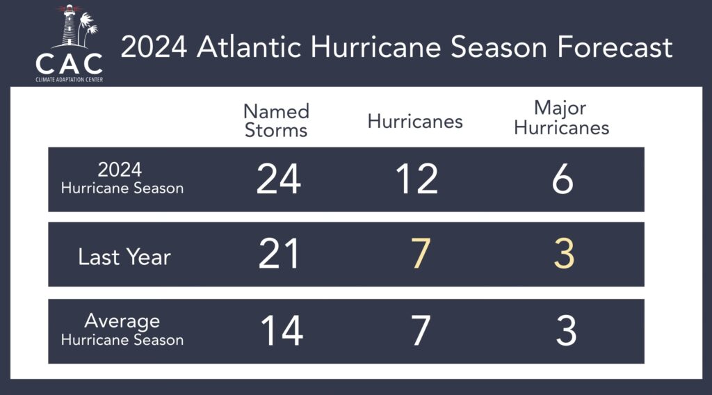
2024 Hurricane Forecast was released on April 4 at 10:50 am EDT and it calls for a very active hurricane season.
NHC data indicates that an average season typically generates 12 named storms, seven hurricanes, and three major hurricanes (Category 3 or higher) from August through November. However, on April 4, 2024, the CAC issued the nation’s first hurricane season forecast, projecting it to be a significantly more active than usual season, with a forecast of 24 named storms, 12 hurricanes, and six major hurricanes.
That forecast hasn’t changed
Bob Bunting, CEO of the Climate Adaptation Center, says, “Sea surface temperatures in the hurricane Main Development Region of the tropical Atlantic and Caribbean are at record or near record warm levels, providing ample fuel for tropical development.” He also notes, “With El Niño dissipated and a neutral and emerging La Niña pattern expected for the peak of the hurricane season, wind shear is likely to be reduced, enhancing tropical storm formation.”
In fact, over 90% of hurricane season activity typically takes place between August and the end of the season, according to the Accumulated Cyclone Energy (ACE) index. The ACE index measures the combined intensity and duration of all named storms throughout the hurricane season.
 In an average season, 12 storms and seven hurricanes form in the Atlantic Basin after July 31. As climate warming plays a significant role, this season is not expected to be average.
Stay informed with the CAC newsletter
To stay informed and up-to-date about hurricane threats to Florida, subscribe to the Climate Adaptation Center’s newsletter below. This resource provides timely updates and expert insights on hurricane activity, helping you stay prepared and informed throughout the season.
By subscribing, you’ll receive the latest information on weather patterns, storm developments, and crucial safety tips to ensure you’re well-equipped to handle any potential threats.